GNU social JP
  • FAQ
  • Login
GNU social JPは日本のGNU socialサーバーです。
Usage/ToS/admin/test/Pleroma FE
  • Public

    • Public
    • Network
    • Groups
    • Featured
    • Popular
    • People

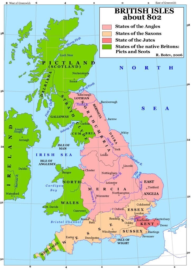
Political map of the BRITISH ISLES about 802, depicting the states of the #Angles, #Saxons, #Jutes, #Picts, and #Scots, not naming the #Gaels of #Ireland and northern #Scotland. Source: https://www.medievalchronicles.com/wp-content/uploads/2020/07/Anglo-Saxon-Kingdoms-Map-724x1024.jpg?bf4fd5&bf4fd5

Download link

https://files.mastodon.social/media_attachments/files/110/061/475/544/581/539/original/a1188f8700d93cff.jpg

Notices where this attachment appears

  1. Embed this notice
    HistoPol (#HP) 🏴 🇺🇸 🏴 (histopol@mastodon.social)'s status on Wednesday, 31-Jan-2024 07:38:25 JST HistoPol (#HP) 🏴 🇺🇸  🏴 HistoPol (#HP) 🏴 🇺🇸 🏴
    in reply to

    @djm_black

    It is time for a #RegionsOfEurope 2.0:

    The present-day territories of the traditional #Saxon, #Celtic, and #Scottish kingdoms of old could all #Rejoin the #EuropeanUnion, like the trendsetters of #EasternEurope. ;)

    Sort of like simultaneously moving the #HadriansWall to enclose all of the #BritishIsles while concurrently eliminating it.

    This would also make any #Ulster and #Scottish questions obsolete.

    Current status:
    https://en.m.wikipedia.org/wiki/Region_(Europe)

    In conversation Wednesday, 31-Jan-2024 07:38:25 JST from mastodon.social permalink
  • Help
  • About
  • FAQ
  • TOS
  • Privacy
  • Source
  • Version
  • Contact

GNU social JP is a social network, courtesy of GNU social JP管理人. It runs on GNU social, version 2.0.2-dev, available under the GNU Affero General Public License.

Creative Commons Attribution 3.0 All GNU social JP content and data are available under the Creative Commons Attribution 3.0 license.